Short descriptions: Dutch Forts of Colombo, Mannar and Katuwana
Extract from Chryshane Mendis's MA Thesis titled "Fortifications and the Landscape: A GIS Inventory and Mapping of Kandyan and Dutch Fortifications in Sri Lanka" , 2020, University of Amsterdam.
Colombo
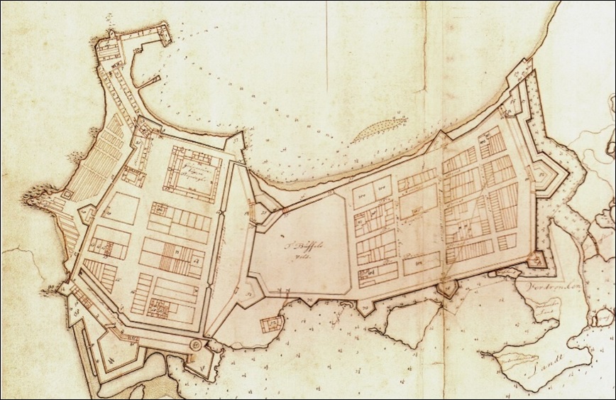
Colombo served as the capital city of the Portuguese
territories and was a large fortified city. It was taken by the Dutch after a
lengthy siege in May 1656 and soon after garrisoned. By the end of the 1650s
some of the Portuguese fortifications had been rebuilt however it later was
decided to completely rebuild the city, restructuring the entire urban fabric.
As such much of the Portuguese city, buildings and all were demolished between
the 1660s and 1670s and by the end of that decade a completely new city had
been built more or less within the urban space of the Portuguese city. Dutch
Colombo was divided into two fortified entities, the main Castle (Casteel)
on the west and a fortified town to the east known as the Old City (Oude
Stad). The bastions and ramparts of the Old City were however demolished by
them at the end of the century. The Castle functioned from then on as the sole
defence work of Colombo. It comprised of an irregular polygon defined as Type
08 and comprised of nine bastions and was further linked to two gun batteries
on the harbour arm by two lines of fortified warehouses. Colombo is classed as
a Main fort category 01 functioning as the main administrative, economic and
military center of the all the VOC territories of Sri Lanka as it was the seat
of the Governor and main port. The Castle housed the garrison, the Governor’s
residence, offices and residential buildings of senior company officers, a
stables, a school, a hospital and a church. The buildings on the harbour arm
functioned as warehouses and workshops relating to shipping. The Old City was
designed into 16 blocks on a grid pattern and was sold for private ownership.
It was chiefly a residential area and comprised of houses for the Burghers[1],
an orphanage and seminary, a hospital, a school for the natives and the
cemetery.
Colombo was taken over by the British who continued
to maintain its fortifications until the mid-19th century where
between 1869 and 1871 much of the eastern and southern works were taken down
for the building of new military barracks. The northern and western defence
works gradually became isolated amounting to eight locations at present.[2]

Fig. 12 Remains of the Slave gate,
a postern gate located on the western ramparts (Author, 2016).

Mannar

Fig. 14 Plan of the fort
of Mannar ca.1722 (Netherlands National Archives. 4.VEL 993)

Katuwana

Fig. 16 Plan of archaeological investigations at Katuvana fort, 2000 ((Jayasena, 2006).
Katuvana is a small inland frontier
fort classed as a Secondary fort category 03: primarily to defend the VOC
territory with the capacity for storage. It is a square stone fort with two
diagonally opposite bastions and located on the eastern bank of the Urubokka
Oya.[1]
Katuvana is first mentioned as a field fortification in 1661 with the stone
fort being built from 1679 to 1681.[2]
The annotations on a plan of Katuvana in the map 4.VEL
1075 (Netherlands National Archives) and dated to ca. 1695, are listed as the guardroom, two
sergeant’s rooms, a small house for the constable, an arsenal, a powder house,
a provisions store, and a well.[3]
Katuvana was abandoned in the early 19th century under the British
but had managed to survive in its entirety and was the first VOC fort to be
systematically excavated in 2000 by the Amsterdam Archaeological Center of the
University of Amsterdam and the Postgraduate Institute of Archaeology (PGIAR)
of the University of Kelaniya Sri Lanka.[4]


Katuwana
[1]
Oya - Sinhalese word for small river.
[2]
Jayasena,
R. M., 2006. The historical archaeology of Katuwana, a Dutch East India
Company fort in Sri Lanka p.116
[3]
Translations from Diessen,
R. V. and Nelemans, B., 2008. Comprehensive Atlas of the Dutch United East
India Company Vol. I p. 165
[4]
Jayasena,
R. M., 2006 p.117
Mannar
[1] Based on photographic
evidence. The gate has been completely destroyed possibly during the recent
civil war.
[2] Translations from Dr. Lodewijk Wagenaar
Colombo
[1] Burghers were the citizens of VOC
territories – Europeans who were traders and businessmen.
[2]
Based on the author’s research on Colombo in the
upcoming book COLOMBO The History of its Fortifications.


Comments
Post a Comment