Short insights into some selected Dutch forts and watch posts
Some interesting snippets of selected Dutch forts and watch posts: Anguruwatota, Arandara, Arippu, Arugambay, Bibilegama, Chilaw, Chundikulam, Gonavila, Iluppaikkadavai, Kananvila, Malwana, Puttalam and Ratnapura.
By Chryshane Mendis
Anguruwatota

Fort of Anguruvatota by J.C. Toorzee, 1688 (Diessen, 2008; Centrale Bibliotheek Rotterdam 86L8)
Located on the right bank of the Kalu Ganga, it guarded the road northwards towards Malwana. It was established by the Dutch in 1653 but abandoned by the end of the century. Anguruwatota was probably also used by the Portuguese.
1653 – “While the army was resting, news was brought that the Hollanders had erected a strong stockade of wood at Angora- tota, and garrisoned it with a hundred and forty men…On reaching Angoratota he found them strongly entrenched with the necessary de¬ fences, redoubts, flanks, and a moat which protected the fortification…” p.163/164, Ribeiro
12th October 1677 sent to Anguratot. “…it was very strong, and well provided with cannon. A
very fine river runs before it, which comes from Saffrigam, and hath great
store of good fish, and tortoises; and we have some thousands of inhabitants
about us, of whom we bought choice fruits very cheap, an all other sorts of
victuals…The Europeans that live here, who are not above forty or fifty in
number…Out of the fort every one hath his little House, where each of them
keeps his Cingulayith woman…” p.300, Christopher Schweitzer
Arandara

Arandara was a fort established on the Colombo-Kandy high way
during the first Kandy-Dutch war between 1665 to 1675. It was a square fort
with four bastions. This fort was besieged successfully by the Kandyans in
1670.
1666. “In the year MDCLXVI. the Hollanders came up and built
a Fort just below me, there being but a ridge of Mountains between them and me.
But tho so near, I could not come to them, a Watch being kept at every passage.
The King sent down against them two great Commanders with their Armies, but
being not strong enough to expel them, they lay in these Watches to stop them
from coming up higher. The name of this Fort was called Arrandery. Which
altho they could not prevent the Dutch from building at that time.
Yet some years after when they were not aware, they fell upon it and took
it, and brought all the People of it up to Cande, where those that
remained alive of them were, when I came from thence.” p. 142, Robert Knox
Arrippu
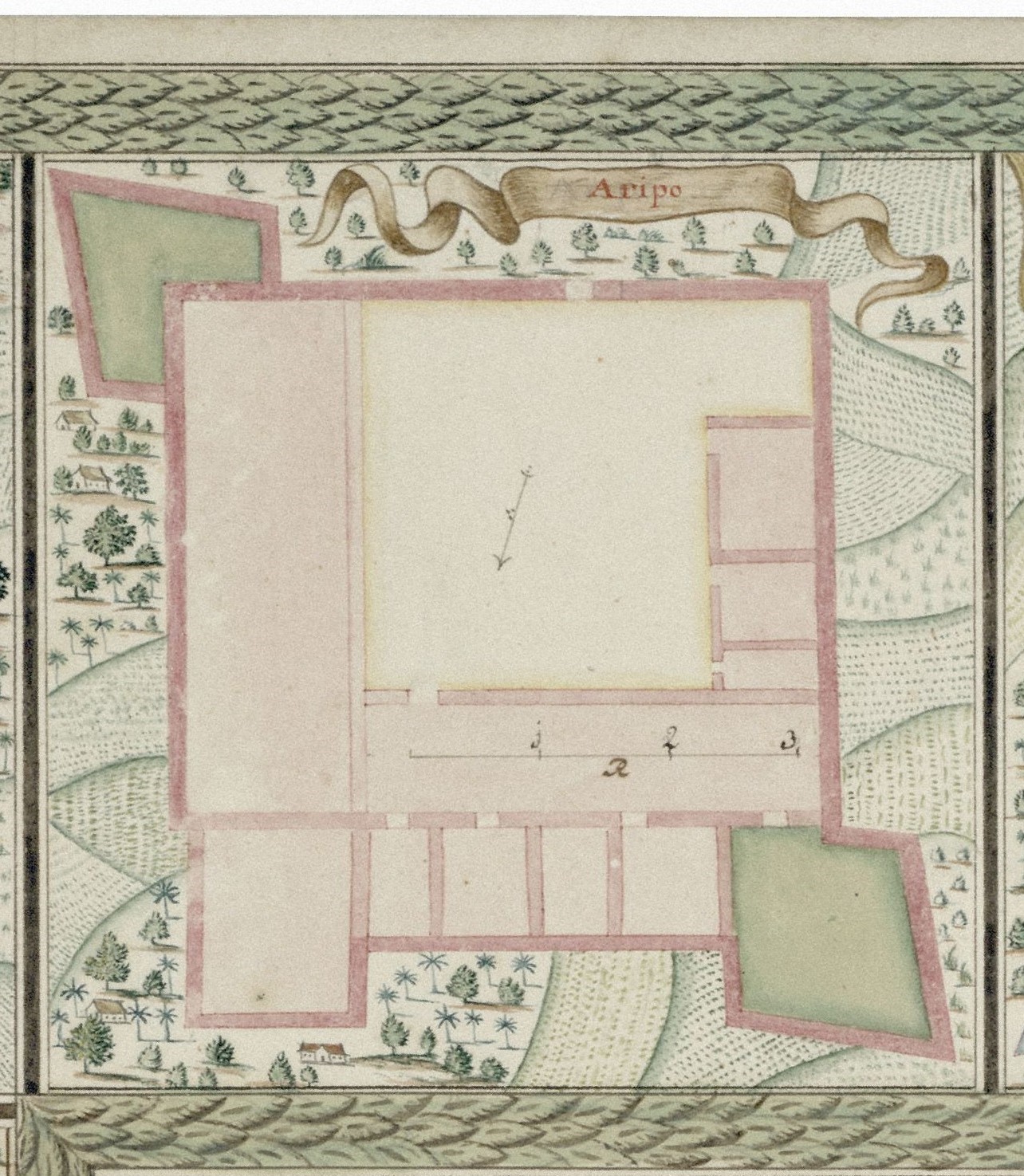
Arippu was first a guarded church probably of Portuguese origin just like Kalpitiya. In 1667 it was redeveloped into a proper fort. Substantial remains of the fort can still be seen today.
1678 - “We arrived all at Aripen about 3 of the clock in the
afternoon…Aripen is a pretty strong place, kept by 20 Dutch soldiers provided
with 4 field-pieces, and other warlike necessaries…This place is chiefly
designed to keep the Pearl bank…It is very unhealty there, and no European but
must expect a fever that will kill him, if he stays there long.”p.307,
Christopher Schweitzer
Arugam Bay
This was a temporary watch post which was occupied
during the first Kandy-Dutch war but abandoned afterwards. It was
re-established during the second war. It is also referred as Apretotte,
Aroekgamma, and Heldeoje. Raven-Hart (1964) in his index states “the
fort lay with the mouth of the Heda Oya to the south, the lagoon bay to the north”
– this location is indicated in the maps of VELH 326 and VEL 925 as well.
Therefore it is possible that the post was on the small hillock forming the
south end of the bay.
Bibilegama
Bibilegama was a fort established during the first Kandy-Dutch war
between 1665 to 1675. It was successfully besieged by the Kandyans in 1675. Raven-Hart
(1953) states that the fort was ½ mile to the southeast of Godakavela.
16xx. “His Craft and Success in taking Bibligom Fort in
the County of Habberagon, may deserve to be mentioned…brought them just
under the Fort, and then to have set it on Fire, the Walls of the Fort being
for the most part of Wood. There was also a Bo-gahah Tree growing
just by the Fort: on which they planted Guns and shot right down into them. The
houses in the Fort being Thatched, they shot also Fire-Arrows among
them…The Fort they demolished to the Ground, and brought up the Four Guns to
the Kings Palace”.p.180, Robert Knox
Chilaw
Chilaw appears to have been fortified twice, first
around 1675 during the first war with Kandy but later abandoned at the turn of
the century. Chilaw was again fortified during the second war in 1762 to which
there is more concrete evidence.
These descriptions are from Raven-Hart (1964) The Dutch Wars with Kandy 1764-1766 – “About 250 men garrison – p.45; 8/3/1764 – the fort is too large…the breastworks are of thorn bushes; 11/3/64 – the fort lies an hour from the river mouth and smuggling cannot be hindered”
1783 –“There is here an old fort, small, and of square form…the guns of the fort command the banks of the river, and can prevent its being approached.” p.68/69, Haafner.
Raven-Hart gives a reference to the site of the fort
in a codex in the Dutch archives of the Sri Lanka National Archives (4892,
5/1/63) however this could not be accessed during the writing of this thesis.
Concerning its exact location, Dr. Ranjith Jayasena states that the present
Police station is housed in part of the fort which retains a strongly built
complex of masonry; however local tradition states the location of the fort as
being of the present Court complex, which is about 850m to the east of the
Police station.
Chundikulam

This site is known as Pas op Tredale/De schans Passeco on various 17th century maps and depicted at a point where the Jaffna peninsula joins the mainland on a thin isthmus. This appears to have been an early fort meant to defend the Jaffna peninsula, probably being established soon after the conquest of Jaffna in 1658. It appears to have been abandoned when the triple forts of Elephant Pas, Pas Beschuter and Pas Pyl were established by the end of the century for the protection of the peninsular.
This site was most positively identified as present
day Chundikulam by the map of Jaffna in Governor De Heere’s journal (map no.
HaNA 1.04.02-1604B-0243). This accurate map depicts an unnamed fort in the
present area of Chundikulam, which could most probably be the site noted as Pas
op Tredale in other maps.
Gonavila
Gonavila was a large fortified camp of the Dutch which
functioned as their base of operations during their offensive campaigns in the
1760s war. Raven-Hart (1964) states that the camp lay east of the present
village of Gonavila (a village just west of Pannala) and just west of ‘the
unnamed tributary’. This site is located on the right bank of the Maha Oya.
Iluppaikkadavai

Not much is known of this fort although a plan of the fort named Ilipkkarwe exists. The only archival map of the island depicting this post is the map VELH 328. Through its location in this map and tracing through present topographic maps, it is most likely that Ilipkkarwe is Iluppaikkadavai which is a village on the northwestern coast which is about 30km to the north of Mannar. This post is also mentioned in the travel diary of Governor Isaac Rumpf in 1719 mentioning his stop over there. Hence it is possible that it was in the center of the village.
Kananvila (Caudingelle)

Fort of ‘Koudangelle’ by J.C. Toorzee, 1688 (Diessen, 2008; Centrale Bibliotheek Rotterdam 86L8)
This fort was established probably in the mid-1650s but abandoned
by the end of the century. It was along the road from Malwana to Anguruwatota.
1st October 1677 – “left for Caudingelle 6 leagues from
Galture with 40 Europeans and 200 Sinhalese…We found the said fort overgrown
with Trees and Shrubs, and no inhabitants within two leagues of it…The
Hollanders had built this fort some years since; but having not made it strong
enough, and provided it with necessaries sufficient, they were forced to leave
it. It takes up about two acres of land; it hath four bastions, a parapet, and
pallisado’s as high as a pike, and as thick as a man’s middle…Our Magazine was
stored with salt, rice, bacon, flesh, brandy, powder and shot, all of which we
had from Anguratot, two leagues distant from us…our water was fetched about a
pistol shot from the fort. After we had lain here eight days in this wild and
desert place, the Candians came against us…we found then it was high time to
remove our quarters, which we did, setting all on fire and retired to…” p.299,
Christopher Schweitzer
Malwana

1st July 1678 goes to Malvane. “I was obliged to go to a little fort called Malvane, 4 leagues from Columbo, where I remained four months. The place is very strong, by a river, it hath Pallisado’s, Parapets, and a ditch, eight field-pieces, and other necessaries and sixty men to keep it.”p.302, Christopher Schweitzer
Puttalam
Puttalam appears to have been fortified twice just as with Chilaw, first around 1675 during the first war with Kandy but later abandoned at the turn of the century. It was again fortified during the second war in 1762 to which there is more concrete evidence.
1783 – “There is a small fort with four bastions, still in tolerably good repair, but quite forsaken and miserable; the garrison, consisting of fifty soldiers, chiefly Topazes and Lascars, live in the village.” p.65/66, Haafner.
Modder (1908) quoting a description of the fort in the 1760s states that the fort was on the south side of the town of Puttalam.
Ratnapura
The exact site of the Ratnapura fort, also known as the Sabaragamuva fort, is debated at present. The present British period fort which was built in 1817 and located in the center of the town is commonly identified as the Dutch fort, however Raven-Hart (1953) states that the Dutch fort was built on the site of the Portuguese fort, which is now the Maha Saman Devale (Temple) premises. Considering that the Dutch arrived at Ratnapura in the late 1660s, which is just about two decades after the Portuguese left Ratnapura, it is possible that the Portuguese fort still remained and which they may have redeveloped. Further according to Herport (1665), one of the participants in the construction of the fort, there were two strong batteries with two guns each (Raven deer 1953: 33). This indicates a square floor plan with two opposite bastions just as the Portuguese fort (of which there is a ground plan).


Comments
Post a Comment